Mural celebrates Tonga Island Marine Reserve
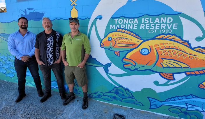
Kaiteriteri Recreation Reserve chief executive Mason Fitzgerald, left, artist Mat Tait and DOC marine reserve ranger Stew Robertson stand beside the new mural that offers a “glimpse into the marine world”, in celebration of the 30th anniversary of the Tonga Island Marine Reserve. Photo: Supplied
Kaiteretere has an extra splash of colour this summer from a new mural celebrating the Tonga Island Marine Reserve.
The mural, which celebrates the reserve turning 30 years old in 2023, is located on the Kaitere facilities block near the boat ramp.
It shows a vibrant underwater scene representing the iconic marine reserve that runs along 11km of the Abel Tasman Coastline.
Featured on the mural are taonga species such as kekeno/NZ fur seal, tāmure/snapper, koura/crayfish and rāwiri/blue cod, alongside other species and habitats.
It also educates boaties and the public about the rules of the reserve. DOC Marine Reserves Ranger Stew Robertson says the mural is a real joint venture, with the concept design coming from liaising with artist Mat Tait.
“Mat is a national treasure in his own right, famous for his art, illustrations and award-winning books. A huge thanks to Kaiteriteri Recreation Reserve which funded Mat’s time, and Dulux which provided the paint through its partnership with DOC.”
The Tonga Island Marine Reserve was established in 1993 to reverse declining populations and a degrading marine ecosystem along the Abel Tasman Coast.
Stew calls the reserve a “spectacular success”, with significant increases in size and abundance of species like rāwiri, kōura and blue moki.
Stew explains that nature thrives as an interconnected system, “and we need to work together to protect it”.
“Diving and boating are encouraged in our reserves but fishing is strictly prohibited. The rules are simple: no fishing, taking, damaging or polluting of marine life inside a marine reserve.”
He says that ignorance is no excuse, with a default penalty of $600, and prosecution and imprisonments for serious, commercial or repeat offending.
The reserve’s boundaries run from Mosquito Bay reef in the south to Awaroa Head in the north, to one nautical mile (1.8km) out to sea. There are yellow triangular markers on land and yellow buoys with crosses and lights at sea along each end out to the corners.
CCTV cameras are installed to detect illegal fishing, and rangers and locals often patrol the reserve at any time of the day or night.
All New Zealand marine reserves are marked on modern vessel chart plotters.
The Marine Mate App also contains the local rules and regulations throughout the country.
“Marine protection allows areas to have intact food webs which builds ecosystem resilience and benefits the surrounding areas,” Stew says.
“Aside from protecting fragile habitats and increasing their resilience, marine reserves give us a glimpse into the marine world without the influence of fishing.”
Editor's note: The spelling of Kaiteretere in this article is how DOC, as author, recognises the spelling. We understand it looks confusing with the spelling of Kaiteriteri also in the article when referring to Kaiteriteri Recreation Reserve - the name of a business.